Sherkin Island
Introduction
Sherkin Island is situated a short distance from Baltimore, Co. Cork . Placed between Ollean Clere and the mainland it is easily reached by boat from Baltimore Harbour, at the cost of 50p approx. (1975). The ferry crosses many times a day and lands at the Harbour, Abbey Strand. Camping is possible in this vicinity and is conveniently close to the island's three pubs, the hotel, the Harbour Lights and the Jolly Roger. Permission for camping in the vicinity of the Abbey should be sought from Mr. O'Neill at the Post Office.
The recorded climbs have mainly been developed for and during instructional courses. Consequently, many more difficult climbing opportunities have had to be ignored. What has been done, is however, very worthy and pleasant. The rock is rather light coloured slate with quartz bands. The cracks tend to be shallow and the walls abound in flakes. There is little poor rock on the crags and what there is can be easily identified.
The climbing lies along a stretch of coast from Horseshoe Bay westwards. First is "the Lug" a short interesting area. Half a mile further west is "Coosacoam" a narrow gorge 30 ft high and an ideal spot to teach basic principles, rope work, abseil, etc.
One mile futher west over the summit ridge of "Slieve Mor" the island's highest point is "Poulcurra", a most dramatic and as yet unclimbed 250 ft high cliff.
West across the slope opposite "Poulcurra" is the most extreme south-west tip of Sherkin, "Cooseenaceol'". Here 50 yards below the end of the wall-cum-fence, are cairns and an obvious base from which to climb. The alternative approach to this point involves taking the road to the church to Tracrua (approx. 1 mile) from there walk south into the next bay and then follow the coast line around above cliffs of increasing size to the spectacular pinnacle or sea stack "Stuckanboy". The highest point of the coast is a little further on and the ridge to the cairns descends from here. No known problems exist in regard to access on Sherkin provided the semi-tracks are used to reach the open country of the coastline.
Cooseenaceol
The routes are described from right to left on the south section from the easy way down. They are described from left to right on the north section. A four star system of recommendation has been used.
South Section
Fad Amach Fear 10m HVS 5a
15 m R of the usual descent to 'Wetton Wall' area there is a 10m triangular wall with three cracks. Climb the L-hand crack, crux at mid-height.
S. O'Riordan, D. O'Connell 18th June 1982.
WETTON WALL 70ft VS
S. Manning, M. McDonagh, Easter 1973
The steep wall is climbed to a break then a shallow crack to the top.
CAPTAIN'S CRACK ** 70ft S
N. Allen, S. Manning, M. McDonagh, Easter 1973
The obvious crack 15 ft left of Wetton Wall. It is almost a chimney at first. Another moderate scramble is left of last and 50 ft left is a short steep corner above a small pool.
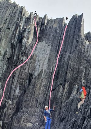
A. BLOOD LINE 20m HS4b
Start just L of the descent route, below a notch in the top of the wall. Climb steeply to the notch.
P. O'Brien, R. Garvey 3/8/24
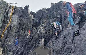
B. SHAKIN SHERKIN 25M HS4a
Start to the L (facing in) of the descent route, in at the foot of a corner, below and L of a prominent pale patch on the upper section of the wall.
Climb up to a ledge then diagonally R on small holds to reach an obvious foothold L of and level with the bottom of the pale patch. Up steeply from here to the top.
C. McGovern, G. Moss. 3/8/24
QUARTZ SLAB 110ft Diff
N. Allen, S. McDonagh, Easter 1973
1. 30 ft Climb the steep corner to ledge
2. 80 ft Descend the pleasant quartz slab
3. 85 ft Climb the steeper corner left joining quartz slab at two thirds. very difficult.
On the corner of the buttress left of Quartz Slab are two corner grooves. The first one is:
STEPPED CORNER * 80ft Diff
W. Cunningham and party Easter 1973
From the easy angled slabs climb the corner direct.
JAGGED CORNER * 100ft Diff
N. Allen Easter 1973
To the left and lower is a chimney crack from sea ledges.
1. 25 ft Climb the crack or wall on the right to a stance on the right.
2. 7 5 ft Climb the corner above.
WILLIE 'S ROUTE * 160ft S
W. Cunningham and party Easter 1973
1. 35 ft Climb the wall for a few feet left of last chimney to a break. Poor belays.
2. 65 ft Ascend the wall to an exposed move right to finish. It is possible to move into black chimney, this is a poorer finish. The narrow rib on right is an alternative
BLACK CHIMNEY 100ft V.Diff
W. Cunningham and party Easter 1973
To the left of Willies Route at 50 ft move out right to a slabby finish.
Unnamed
N. Allen Aug 1975
Across a cleft to more ledges below a magnificent wall, with a crack at its right hand side
RESERVE *** 110ft VS
N. Allen, M. McDonagh Aug. 1975
1. Climb the wall 20 ft left of the crack to move up a third crack to a fine ledge, poor belay.
2. Traverse right into the crack which is climbed direct to an awkward finish, stance on the right.
Reservation 24m HVS 5a.
This is a direct start to 'Reserve'. Climb the strenuous fingercrack for 14m (crux) to join the corner of 'Reserve' where the angle eases.
D. O'Connell, S. O'Riordan 18th June 1982.
It is not often possible to traverse the cave at this point to the next feature, Devil's Kitchen and the Northern Area. All climbs are therefore described from the descents to this section.
North Section
Travel 250 feet along and up the ridge from the cairns to where the wall-cum-fence ends. Cross the wall and locate an 80 ft. moderate slab descent. Alternatively scramble down the ridge on the right (facing out) to a stake. Descend by reverse mantleshelves to easy slabs at the foot of the cliff. The first route, moving right, is a cracked slabby wall.
LIMERICK LADDER 100ft Diff
S. Manning and party Easter 1974
Climb the cracked wall, pleasantly, to a steep finish.
DOCTOR'S CHOICE 110ft V.Diff
S. Manning and party Easter 1974
Start: To the right is a shallow chimney
1. 70 ft Ascend to a corner just inside the ridge. Climb this and grooves above to stance.
2. 40 ft Climb the wall to the ridge and finish either direct or move right to an easy corner
to finish.
WHITE WALL ** 120ft V.Diff
N. Allen Easter 1973
Start: Move around a corner right of Doctor's Choice to a narrow slab.
1. 60 ft Climb the slab and a short chimney to a ledge. Move up to larger ledge and stance below a white wall.
2. 60 ft Ascend the wall direct on large holds to a rising traverse to the right, to finish at a short corner.
DEVIL'S KITCHEN ** 120ft Diff
N. Allen Easter 1973
Start: The main feature of this area is an unpleasant looking amphitheatre. The ascent of which is this climb.
1. 30 ft Scramble up easy slabs to a pool.
2. 40 ft Climb across the right wall to a stance and piton belay in the corner.
3. 50 ft Climb to the right and ascend slabby corner to the top.
WHITE WALL CORNER 90ft HS
N. Allen Aug. 1975
Start: From the pool on Devil's Kitchen on the left wall.
1. 40 ft From the pool ascend the wall direct to a stance below a steep corner right of White Wall.
2. 55 ft Ascend the corner direct.
DEVIL'S GROOVES 95ft HS
N. Allen Aug. 1974
Start: As for White Wall Corner. At 30 ft move right into shallow grooves on the left wall of Devil's Kitchen. Ascend direct to a steep finish.
Stuckanboy
This is the spectacular pinnacle halfway along the coast between Tracrua and Cooseenaceol. The landward connection of the pinnacle is reached by abseil.
ORIGINAL ROUTE 70ft HS
R. Leek and party Aug. 1974
Traverse across ledges to the south side and the wide crack/cleft to the narrow summit. Descend by a contrived abseil. A very serious venture.
The Lug Area
The best climbing here is in the gorge nearest Horse Shoe Bay. Descend down a black chimney or approach from the sea. There are three routes on the east side, severe, very difficult and difficult and one route on the west side, 55 ft severe. On the western section of the Lug there is a good 60 ft corner, severe grade, 150 ft along a sea level traverse from the sea and three other less worthy routes.
Coosacoam
This is a short but very good value training crag with seven climbs on the east side, ranging from difficult to severe. On the west side the obvious crack is very difficult. The central ribs on the east side at mild severe is the best climb here. This crag can be approached by crossing the ridge above the island's water supply tanks descending a prominent gully to the crag at sea level.
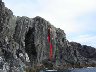
I'm not sure if these are new routes or not, but couldn't elucidate them from the existing guide so I thought I'd hand it over to the local experts. We climbed 2 routes on 18th August on what I believe is the Cooseenaceol area of Sherkin Island on what is referred to as the 'South Section'.
Both routes start up the crack line below the arete which is approximately 1/3 of the way along the main wall from the right hand side. Route 1 breaks off left and follows the curving corner crack to the top before exiting to the right (similar to the described existing route 'Reserve'). Consensus of the party was VS 4c. Route 2 follows the crack line immediately right of the arete and follows this directly to the top. Split opinion left us between VS 4c and HVS 5a. Both routes were led by myself and seconded by Craig Woods and Tom Matthews.
If new we came up with the names 1. Waiting for the Sun 2. Bangor Beta.
I would be interested to know if these routes have been climbed before. Find attached a photograph topo with the routes marked. If you would like to publish the photo to the web page I can provide an unedited or higher resolution file.
All the best,
Neil Mullinger


