Difference between revisions of "Coumshingaun"
| (One intermediate revision by the same user not shown) | |||
| Line 1: | Line 1: | ||
| − | [[File:Coum.jpg|200px|Coum.jpg]]<br/>Perhaps the finest example of a corrie or coum in Europe, Coumshingaun is the most famous landmark in the Comeragh mountains. | + | [[File:Coum.jpg|200px|Coum.jpg]]<br />Perhaps the finest example of a corrie or coum in Europe, Coumshingaun is the most famous landmark in the Comeragh mountains. |
'''Approach''' - It is best approached from the Carrick on Suir to Dungarvan road. The most traditional and most gentle approach involves parking at Kilclooney bridge (GR. 348115), entering through a gate to the west, crossing a stream from which a vague path may be followed to the west. This track is more defined once you gain the open mountain. | '''Approach''' - It is best approached from the Carrick on Suir to Dungarvan road. The most traditional and most gentle approach involves parking at Kilclooney bridge (GR. 348115), entering through a gate to the west, crossing a stream from which a vague path may be followed to the west. This track is more defined once you gain the open mountain. | ||
| Line 6: | Line 6: | ||
[[File:Cs map.jpg|RTENOTITLE]] | [[File:Cs map.jpg|RTENOTITLE]] | ||
| − | |||
| − | |||
<display_map> | <display_map> | ||
| Line 14: | Line 12: | ||
52.24646, -7.522779~North-facing cliff | 52.24646, -7.522779~North-facing cliff | ||
52.244945, -7.500884~Kilcooney wood carpark | 52.244945, -7.500884~Kilcooney wood carpark | ||
| − | 52.248771, -7.515163~AC Buttress | + | 52.248771, -7.515163~AC Buttress. |
</display_map> | </display_map> | ||
Climbs denoted by ##### were all climbed pre-1964 and were logged in various Irish Mountaineering Club journals of that time. However, the route descriptions have proved to be rather vague and attempts to located them has by and large proved to be inconclusive. Climbs 51, 52, and 53 are all thought to follow roughly the same line on the left (west) of the cliff. Some or all of these route may in part be repeated or contained in some of the other routes in this guide. | Climbs denoted by ##### were all climbed pre-1964 and were logged in various Irish Mountaineering Club journals of that time. However, the route descriptions have proved to be rather vague and attempts to located them has by and large proved to be inconclusive. Climbs 51, 52, and 53 are all thought to follow roughly the same line on the left (west) of the cliff. Some or all of these route may in part be repeated or contained in some of the other routes in this guide. | ||
| − | == Links to route descriptions == | + | ==Links to route descriptions== |
[[North-facing_Cliff|North-facing Cliff]] | [[North-facing_Cliff|North-facing Cliff]] | ||
| Line 29: | Line 27: | ||
[[AC_Buttress|AC Buttress]] | [[AC_Buttress|AC Buttress]] | ||
| − | == Boulder Problems == | + | ==Boulder Problems== |
[[Boulder_Problems|Boulder Problems]] | [[Boulder_Problems|Boulder Problems]] | ||
Latest revision as of 15:43, 11 March 2021

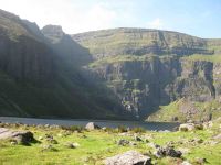
Perhaps the finest example of a corrie or coum in Europe, Coumshingaun is the most famous landmark in the Comeragh mountains.
Approach - It is best approached from the Carrick on Suir to Dungarvan road. The most traditional and most gentle approach involves parking at Kilclooney bridge (GR. 348115), entering through a gate to the west, crossing a stream from which a vague path may be followed to the west. This track is more defined once you gain the open mountain.
An alternative and shorter approach involves parking at Kilclooney wood (GR. 342103), follow a track through the woods from the north west corner of the car-park until you meet a forest road, turn right and follow this to the forest boundary, follow the fence to the corner of the forest from where some sheep tracks may be followed to the lake. This latter approach saves about fifteen minutes.
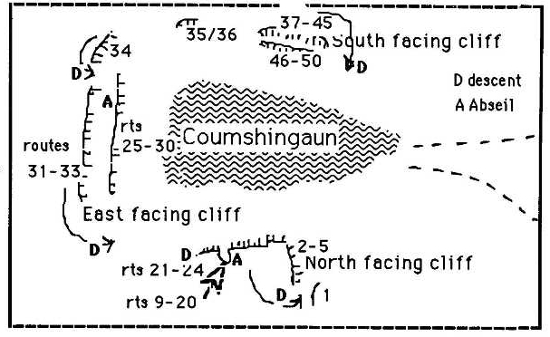
Climbs denoted by ##### were all climbed pre-1964 and were logged in various Irish Mountaineering Club journals of that time. However, the route descriptions have proved to be rather vague and attempts to located them has by and large proved to be inconclusive. Climbs 51, 52, and 53 are all thought to follow roughly the same line on the left (west) of the cliff. Some or all of these route may in part be repeated or contained in some of the other routes in this guide.
