Difference between revisions of "Clare Island"
(Formatting) |
|||
| Line 8: | Line 8: | ||
'''Accommodation.''' You have a choice. Less than five minutes walk from the landing pier, and directly above the blue flag beach, is the island's only campsite. Small and basic, campers have the use of the community centre's toilets and wash-hand basins, located just 50m from the campsite. Alternatively (and this was our choice and highly recommended), you can opt for the spanking new hostel situated just beyond the campsite, check out www.goexplorehostel.ie. The hostel has a bar attached, and serves meals, specialising in fish freshly caught each day by the manager, Carl.<br> | '''Accommodation.''' You have a choice. Less than five minutes walk from the landing pier, and directly above the blue flag beach, is the island's only campsite. Small and basic, campers have the use of the community centre's toilets and wash-hand basins, located just 50m from the campsite. Alternatively (and this was our choice and highly recommended), you can opt for the spanking new hostel situated just beyond the campsite, check out www.goexplorehostel.ie. The hostel has a bar attached, and serves meals, specialising in fish freshly caught each day by the manager, Carl.<br> | ||
| − | '''Getting around the island.''' You can walk, hire a bike (or bring your own) or, if there is a group, hire the island's only minibus. The nearest crag to the harbour is 5k away, not a huge distance, but time consuming if walking. There are bikes for hire at the harbour, but they don't open until 10am so, if you want to get off early in the morning, hire your bike the evening before (they have good bikes and old crocks and they usually try to pawn the crocks on the innocent, so insist on a decent bike). | + | '''Getting around the island.''' You can walk, hire a bike (or bring your own) or, if there is a group, hire the island's only minibus. The nearest crag to the harbour is 5k away, not a huge distance, but time consuming if walking. There are bikes for hire at the harbour, but they don't open until 10am so, if you want to get off early in the morning, hire your bike the evening before (they have good bikes and old crocks and they usually try to pawn the crocks on the innocent, so insist on a decent bike). |
| − | |||
| − | |||
==Toormore== | ==Toormore== | ||
| Line 29: | Line 27: | ||
'''Arch Buttress.''' GR 665 842<br> | '''Arch Buttress.''' GR 665 842<br> | ||
| − | The first route is on the buttress with the prominent arch, almost directly below the end of the fence. Access is gained by scrambling halfway down the sloping ramp which starts a few m. E of the fence, stepping across the narrow channel (easier at low tide), and scrambling up and back right to reach the foot of the arete on the right side (facing in) of the seaward face. N.B. There is scope for more routes on this buttress. | + | The first route is on the buttress with the prominent arch, almost directly below the end of the fence. Access is gained by scrambling halfway down the sloping ramp which starts a few m. E of the fence, stepping across the narrow channel (easier at low tide), and scrambling up and back right to reach the foot of the arete on the right side (facing in) of the seaward face. N.B. There is scope for more routes on this buttress. |
| + | |||
1. '''Arch Arete.''' V. Diff.<br> | 1. '''Arch Arete.''' V. Diff.<br> | ||
''G.Moss, J.Byrne., J.Reville. 26/7/12.''<br> | ''G.Moss, J.Byrne., J.Reville. 26/7/12.''<br> | ||
| − | The right arete of the seaward face of the arched buttress.<br> | + | The right arete of the seaward face of the arched buttress.<br> |
| − | |||
| − | |||
[[image:CLI2aa.jpeg]] | [[image:CLI2aa.jpeg]] | ||
[[image:CLI3a.jpeg]] | [[image:CLI3a.jpeg]] | ||
| + | |||
'''Arch Buttress Wall.'''<br> | '''Arch Buttress Wall.'''<br> | ||
| − | The next five routes are on the wall to the east of Arch Buttress and are reached by scrambling down the sloping ramp mentioned above. The climbs are described from left to right | + | The next five routes are on the wall to the east of Arch Buttress and are reached by scrambling down the sloping ramp mentioned above. The climbs are described from left to right |
| Line 78: | Line 76: | ||
| − | + | ''The following 7 climbs are on the next face to the E and are accessed by scrambling down through a gap in the clifftop about 30 m E of the fence and moving left (facing out) to reach a good ledge system well above the highwater mark. The buttress is characterised by several blocky overhangs.'' | |
| − | |||
| − | The following 7 climbs are on the next face to the E and are accessed by scrambling down through a gap in the clifftop about 30 m E of the fence and moving left (facing out) to reach a good ledge system well above the highwater mark. The buttress is characterised by several blocky overhangs. | ||
7. '''No Brakes.''' Diff.<br>''J. Byrne, J. Reville, G. Moss 26/7/12.'' | 7. '''No Brakes.''' Diff.<br>''J. Byrne, J. Reville, G. Moss 26/7/12.'' | ||
| Line 96: | Line 92: | ||
''J. Reville, J. Byrne, G. Moss 26/7/12.''<br> | ''J. Reville, J. Byrne, G. Moss 26/7/12.''<br> | ||
Start 2m right of 10, below a line of sharp projecting blocks. Climb straight up over the blocks to the top.<br><br> | Start 2m right of 10, below a line of sharp projecting blocks. Climb straight up over the blocks to the top.<br><br> | ||
| − | 12. '''Sucking Diesel.''' V.Diff.<br>''J. Byrne, J. Reville, G. Moss 26/7/12.''<br>Start 2m right of 11, below a wide crack 2m in from the right edge of the face. Climb straight up through the crack to the top.<br><br>13.''' Vantastic.''' V. Diff.<br>''G. Moss, J. Byrne, J. Reville 26/7/12.''<br>This climb follows the right edge of the face. | + | 12. '''Sucking Diesel.''' V.Diff.<br>''J. Byrne, J. Reville, G. Moss 26/7/12.''<br>Start 2m right of 11, below a wide crack 2m in from the right edge of the face. Climb straight up through the crack to the top.<br><br>13.''' Vantastic.''' V. Diff.<br>''G. Moss, J. Byrne, J. Reville 26/7/12.''<br>This climb follows the right edge of the face. |
==Craigmore Area== | ==Craigmore Area== | ||
| − | '''Approach.''' From the cattle grid mentioned above, walk back E along the road to a dip in the road, where there is a gate on the seaward side of the road. Go through the gate and, keeping to the left of the fence, follow it around to a small stile. Cross over here and continue east for a short distance, until it is possible to scramble down to sea level. There is much yet to be done here. In particular, we passed above a tall, narrow buttress on the way in, ignoring it because we thought it was covered in guano, but we realised on the way out that it was, in fact, large patches of quartzite! | + | '''Approach.''' From the cattle grid mentioned above, walk back E along the road to a dip in the road, where there is a gate on the seaward side of the road. Go through the gate and, keeping to the left of the fence, follow it around to a small stile. Cross over here and continue east for a short distance, until it is possible to scramble down to sea level. There is much yet to be done here. In particular, we passed above a tall, narrow buttress on the way in, ignoring it because we thought it was covered in guano, but we realised on the way out that it was, in fact, large patches of quartzite! The first route follows a dark, narrow, undercut slab just above the high water mark.<br> |
| − | The first route follows a dark, narrow, undercut slab just above the high water mark.<br> | ||
| − | |||
| − | |||
[[image:CLI9aa.jpeg]] | [[image:CLI9aa.jpeg]] | ||
| − | + | 14. '''Van Diesel. HS 4b.''' Climbed in two pitches to avoid rope drag.<br>''J. Reville J. Byrne G. Moss 25/7/12.''<br>1. Gain the slab from the left and climb it to a broad platform.<br>2. Move back to the juggy corner behind and climb it.<br> | |
| − | |||
| − | 14. '''Van Diesel. HS 4b.''' Climbed in two pitches to avoid rope drag.<br> | ||
| − | |||
| − | |||
| − | |||
| − | |||
| − | |||
[[image:CLI20aa.jpeg]] | [[image:CLI20aa.jpeg]] | ||
| + | 15. '''Three Point Turns.''' Severe.<br>''J. Byrne, J. Reville, G. Moss 25/7/12.''<br>This climb is found at the foot of a series of corners around to the E of 14. Start at the foot of a biscuit-coloured corner just left of a dark overhang. Climb the corner to a good ledge and continue up to finish through a break in the skyline.<br> | ||
| − | + | <br> | |
| − | |||
| − | |||
| − | |||
| − | |||
| − | |||
| − | |||
| − | |||
Revision as of 15:41, 24 March 2021
Though Clare Island is often bypassed in favour of its larger and better known neighbour, Achill Island, it has a lot going for it and is up there with the best of our offshore islands. For instance, there are some pleasant walking routes on the island and you can choose to ramble up to the highest point, Knockmore 462m , which provides wonderful views of Mayo's coastline, or you can opt to walk along the top of some spectacular sea-cliffs, home to rare flora and fauna, and visit the lighthouse, perched on the edge of the cliffs. Add in a blue flag beach and a very friendly set of locals, and you have enough to make a visit well worth while. As if that wasn't enough, we have now added some fine rockclimbing on the sea-cliffs to the mix.
Jane Byrne, Joe Reville and myself paid a visit during a brief and rare dry spell in July, 2012 to check out some cliffs I had spotted on a previous visit. The result is a collection of easy climbs (nothing over Hard Severe) on perfect rock, and all with good protection. We have only scratched the surface here - with only limited time available we concentrated on the most accessible and most obvious lines - there is plenty more to be done.
Getting to the Island.Contrary to what some of the websites indicate, there is now only one company running a ferry service to the island, (see www.clareislandferry.com.) Campers should note that the ferry company, in keeping with all the ferry companies serving the inhabited islands, and as a result of unruly and disruptive behaviour by campers, does not allow visitors to bring alcohol on to the island. So leave your six-packs at home and support the local economy.
Accommodation. You have a choice. Less than five minutes walk from the landing pier, and directly above the blue flag beach, is the island's only campsite. Small and basic, campers have the use of the community centre's toilets and wash-hand basins, located just 50m from the campsite. Alternatively (and this was our choice and highly recommended), you can opt for the spanking new hostel situated just beyond the campsite, check out www.goexplorehostel.ie. The hostel has a bar attached, and serves meals, specialising in fish freshly caught each day by the manager, Carl.
Getting around the island. You can walk, hire a bike (or bring your own) or, if there is a group, hire the island's only minibus. The nearest crag to the harbour is 5k away, not a huge distance, but time consuming if walking. There are bikes for hire at the harbour, but they don't open until 10am so, if you want to get off early in the morning, hire your bike the evening before (they have good bikes and old crocks and they usually try to pawn the crocks on the innocent, so insist on a decent bike).
Toormore
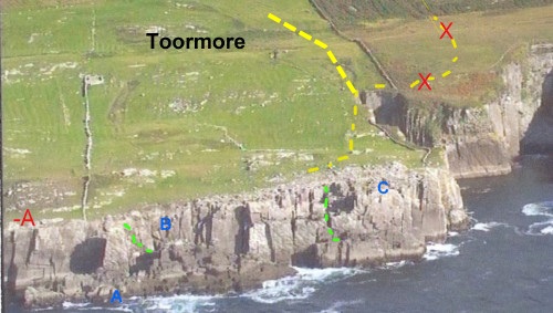
Approach. Follow the road leading west from the harbour for about 5k. to a cattle grid. A short distance beyond this there is a gate in the wall on the left. Do not go through this gate, seek permission from house, further up, on R.H.S. fronting road.--PjlH (talk) 18:21, 14 July 2014 (IST) Go down to the clifftop just short of another fence coming down at right angles to the clifftop. The climbs are described from left to right and are on 4 separate sections, as shown on the photo detailing the new line of approach. ,
A minus = Kernan's Korner Wall, A = Arch Buttress, B = Arch Buttress Wall, C = Choc-a-Block Wall.
Kernan's Korner Wall
50m west of Arch Buttress is a 20m wide Wall with a platform 3m above above high tide mark.
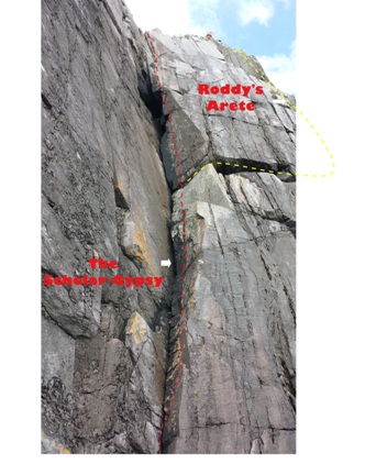
1. The Scholar-Gypsy Diff. 15m
P. Herbert, H. Olsson 06/07/14
From east end of platform, follow continuous crack in groove to the top.,
2. Roddy's Arête Diff. 18m
P.Herbert, H. Olsson 06/07/14
Start as for The Scholar-Gypsy and at 10m step out right on good hand and foot placements to small ledge on arête, continue up the arête or step right onto face to finish.
Scope for more routes on this wall.--PjlH (talk) 17:35, 14 July 2014 (IST)
Arch Buttress. GR 665 842
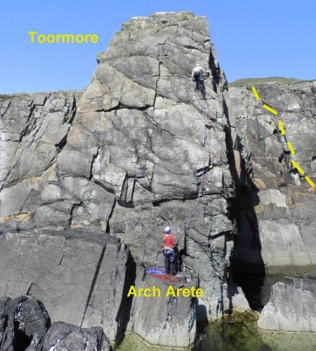
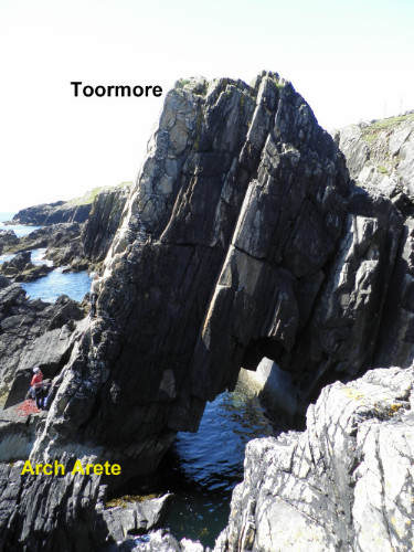
The first route is on the buttress with the prominent arch, almost directly below the end of the fence. Access is gained by scrambling halfway down the sloping ramp which starts a few m. E of the fence, stepping across the narrow channel (easier at low tide), and scrambling up and back right to reach the foot of the arete on the right side (facing in) of the seaward face. N.B. There is scope for more routes on this buttress.
1. Arch Arete. V. Diff.
G.Moss, J.Byrne., J.Reville. 26/7/12.
The right arete of the seaward face of the arched buttress.
Arch Buttress Wall.
The next five routes are on the wall to the east of Arch Buttress and are reached by scrambling down the sloping ramp mentioned above. The climbs are described from left to right
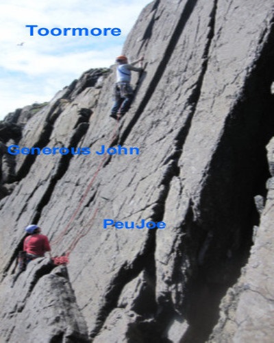
2. Generous John. V. Diff.
J. Reville, J. Byrne, G. Moss 26/7/12.
The lefthand and narrower of two cracks near the bottom of the sloping ramp.
3. PeuJoe V. Diff.
J. Byrne, J. Reville, G. Moss 26/7/12.
The righthand and deeper of the two cracks near the bottom of the ramp.
The next 3 routes are reached by scrambling on down to the bottom of the ramp and stepping across a gap to reach a ledge at the foot of a leftfacing corner.
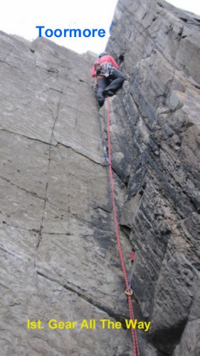
4. First Gear All The Way. V.Diff.
J. Byrne, J. Reville, G. Moss 27/7/12.
Climb the continuous crack in the corner.
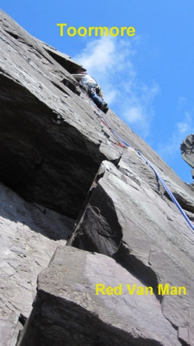
5. Red Van Man. HS 4b.
J. Reville, J. Byrne, G. Moss 27/7/12.
Start as for 4. Step out right and climb the crack just right of the overhang, moving back leftbeneath the small overhang higher up the face.
6. The Pirate Queen. HS 4b.
G. Moss, J. Reville, J. Byrne 27/7/12.
Start as for 4. Hand traverse horizontally right along a thin crack and step up to a good ledge. Climb the thin crack above the right hand end of the ledge, finishing over jammed blocks.
Choc-a-Block Wall.
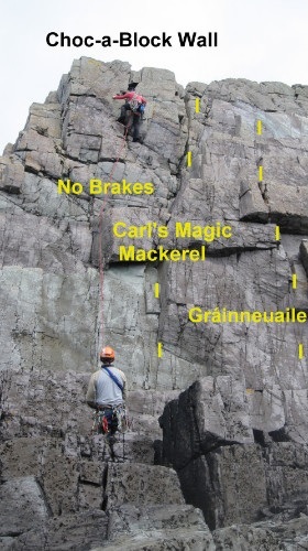
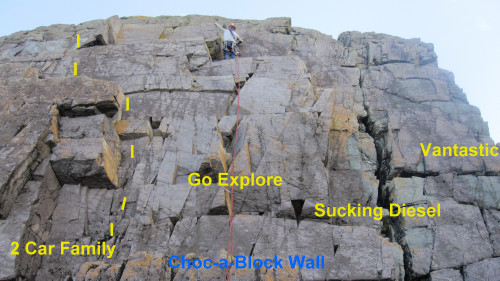
The following 7 climbs are on the next face to the E and are accessed by scrambling down through a gap in the clifftop about 30 m E of the fence and moving left (facing out) to reach a good ledge system well above the highwater mark. The buttress is characterised by several blocky overhangs.
7. No Brakes. Diff.
J. Byrne, J. Reville, G. Moss 26/7/12.
This climb follows a line just left of the line of overhangs, to finish up via a notch in the skyline near the left edge of the face.
8. Carl's Magic Mackerel. M Severe.
J. Reville, J. Byrne, G. Moss 26/7/12.
Start just right of 7. Climb up through a gap in the overhang to gain, and follow, the crack in the upper face, 2m right of 7.
9. Gráinneuaile. Severe.
G. Moss, J. Byrne, J. Reville 26/7/12.
Start 3m right of 8, below a short, left facing corner capped by a blocky overhang. Climb the corner to the overhang, surmount this on good holds and continue straight up.
10. Two Car Family. Diff.
G. Moss, J. Byrne, J. Reville 26/7/12.
Start 3m right of 9, below a short right facing corner capped by an overhang. Climb up just right of the overhang and step left to a good ledge. Move a little left and finish up just left of a projecting block.
11. Go Explore. V. Diff.
J. Reville, J. Byrne, G. Moss 26/7/12.
Start 2m right of 10, below a line of sharp projecting blocks. Climb straight up over the blocks to the top.
12. Sucking Diesel. V.Diff.
J. Byrne, J. Reville, G. Moss 26/7/12.
Start 2m right of 11, below a wide crack 2m in from the right edge of the face. Climb straight up through the crack to the top.
13. Vantastic. V. Diff.
G. Moss, J. Byrne, J. Reville 26/7/12.
This climb follows the right edge of the face.
Craigmore Area
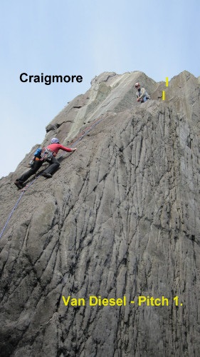
Approach. From the cattle grid mentioned above, walk back E along the road to a dip in the road, where there is a gate on the seaward side of the road. Go through the gate and, keeping to the left of the fence, follow it around to a small stile. Cross over here and continue east for a short distance, until it is possible to scramble down to sea level. There is much yet to be done here. In particular, we passed above a tall, narrow buttress on the way in, ignoring it because we thought it was covered in guano, but we realised on the way out that it was, in fact, large patches of quartzite! The first route follows a dark, narrow, undercut slab just above the high water mark.
14. Van Diesel. HS 4b. Climbed in two pitches to avoid rope drag.
J. Reville J. Byrne G. Moss 25/7/12.
1. Gain the slab from the left and climb it to a broad platform.
2. Move back to the juggy corner behind and climb it.
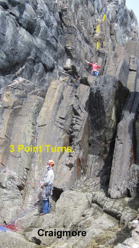
15. Three Point Turns. Severe.
J. Byrne, J. Reville, G. Moss 25/7/12.
This climb is found at the foot of a series of corners around to the E of 14. Start at the foot of a biscuit-coloured corner just left of a dark overhang. Climb the corner to a good ledge and continue up to finish through a break in the skyline.
